


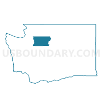
Dale Voting District, Snohomish County, Washington
About
Outline

Summary
| Unique Area Identifier | 689015 |
| Name | Dale Voting District |
| County | Snohomish County |
| State | Washington |
| Area (square miles) | 0.13 |
| Land Area (square miles) | 0.13 |
| Water Area (square miles) | 0.00 |
| % of Land Area | 100.00 |
| % of Water Area | 0.00 |
| Latitude of the Internal Point | 47.86203270 |
| Longtitude of the Internal Point | -122.25563810 |
Maps

Graphs
Select a template below for downloading or customizing gragh for Dale Voting District, Snohomish County, Washington


Neighbors
Neighoring Voting District (by Name) Neighboring Voting District on the Map
- Ash Voting District, Snohomish County, WA
- Jefferson Voting District, Snohomish County, WA
- Madison Voting District, Snohomish County, WA
- Manordale Voting District, Snohomish County, WA